Anthropic says its AI will not be used to spy on customers, even in government contracts. Here is what that means for AI governance, enterprise trust and defence partnerships.
Tropical Cyclone Kenneth has made landfall: everything you need to know

Are you in Mozambique? Is Cyclone Kenneth bearing down on your neighbourhood? Of are you simply searching for answers for the questions you have about the storm?
In this piece, we cover everything you should know about the latest weather system bearing down on Mozambique.
Article last updated at 10pm SAST, 25 April 2019, with additional information from MeteoFrance issued 8pm SAST, 25 April 2019.
When and where did Kenneth form?
Cyclone Kenneth, officially known as Intense Tropical Cyclone Kenneth at present, is a cyclonic storm that formed on 21 April. Back then, it was known as Tropical Disturbance 14, situated north-east of Madagascar. It gained its Tropical Cyclone nomenclature on 24 April after it strengthened, travelling southwest across the Comores into warmer waters.
Where is Kenneth now?
According to Google’s Crisis Map, Kenneth was just a few hundred kilometres from the Mozambique coastline, near the country’s border with Tanzania as of 3pm.
| WV062 Satellite channel |#CycloneKenneth seen just east of the north coast of #Mozambique, #COL to the south-east of #SouthAfrica and #Coldfront to the south-west that will slip south of the country tomorrow.
copyright 2019 @eumetsat pic.twitter.com/41jSXVUrQn— SA Weather Service (@SAWeatherServic) April 25, 2019
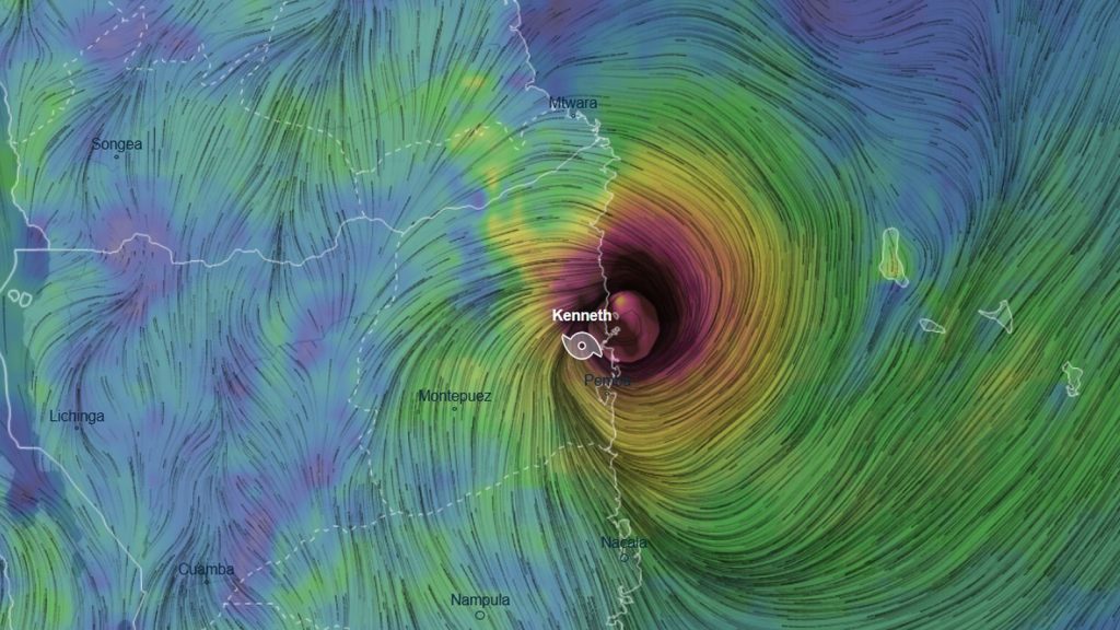
The storm has since made landfall just north of Pemba around 7pm SAST. It is now known as Overland Depression Kenneth.
How strong is Kenneth now?
The storm, as of 3pm, was packing sustained winds of 215km/h — the equivalent strength of a Category 4 hurricane. Gusts of 220km/h had been recorded, according to MeteoFrance.
As of 8pm SAST, the storm is packing maximum winds of 157km/h.
Is Kenneth stronger than Idai?
Yes. Idai peaked at 195km/h. According to AccuWeather, Kenneth is set to become one of the strongest, if not the strongest storm ever to impact northern Mozambique.
When and where will it impact?
The storm has made landfall north of Pemba, Mozambique around 7pm SAST on 25 April.
How strong will it be when it makes landfall?
Projections by Weather.com suggests Kenneth will pack 200km/h winds when it makes landfall. Within 36 hours, MeteoFrance believes that the storm will weaken to 90km/h sustained winds. It is currently packing winds of 157km/h radiating 19km from its centre. Within the next 24 hours, the storm will weaken to 55km/h winds.
How much rain will it drop?
The storm will stall over land this weekend, with some 800mm to 1000mm of rain expected over the northern regions of Mozambique, according to meteorologist Eric Holthaus.
Folks, this is a dire warning for Mozambique:#CycloneKenneth has rapidly strengthened and is now expected to match Cyclone Idai’s peak (125mph/200kph).
After landfall, Kenneth will stall inland—just like Idai—with up to 30in/800mm of rain.
This is a humanitarian catastrophe. pic.twitter.com/eLegwhdrdk
— Eric Holthaus (@EricHolthaus) April 24, 2019
How many people live within the danger zone?
Mozambique’s Cabo Delgado province had a population of 2.3-million in 2017.
Will it impact South Africa?
No, the South African Weather Service has made it clear that the storm will not affect South Africa. It’s currently well north of the country’s most northerly regions, and will likely dissipate over Mozambique.
This is a developing story, and will be updated as more current information is made available.
Feature image: screenshot, Ventusky


