With youth unemployment above 60 percent, South Africa is betting on digital skills to drive inclusive growth. Here is how MICT SETA is positioning the next generation for the Fourth Industrial Revolution.
Update: SAWS issues weather warnings for Cape Town this weekend

Update, 11am, 25 August: The South African Weather Service has upgraded the weather watches to warnings in place across a large swathe of the Western Cape and the Cape Town urban area.
“Western Cape Watches upgraded to Warnings for this weekend (25-26 August 2018),” it tweeted late Friday.
“This include disruptive snowfall for the mountainous regions, localised flooding for the south-western Cape, gale force winds and very cold conditions.”
Have a look at the severe weather alerts for today (25 August 2018). Take care and be safe. pic.twitter.com/FmcxanXpxG
— SA Weather Service (@SAWeatherServic) August 25, 2018
Western Cape Watches upgraded to Warnings for this weekend (25-26 August 2018). This include disruptive snowfall for the mountainous regions, localised flooding for the south-western Cape, gale force winds and very cold conditions. pic.twitter.com/yZV93474GQ
— SA Weather Service (@SAWeatherServic) August 24, 2018
Original article: The South African Weather Service (SAWS) and the Western Cape Government have both issued a weather watch for the province this weekend.
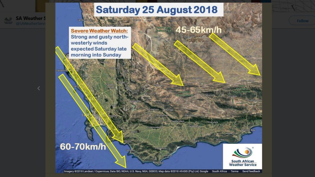
“Some interesting weather expected this weekend in the Western Cape,” tweeted SAWS late Thursday, as the result of a cold front.
Some interesting weather expected this weekend in the Western Cape (25 to 26 August 2018). Have a look below. Stay informed with @SAWeatherServic and follow us on facebook. For more information please go to our website https://t.co/82W3dwEEdB pic.twitter.com/3pyoKe1JJc
— SA Weather Service (@SAWeatherServic) August 23, 2018
Said “interesting” weather conditions will include “strong and gusty north-westerly winds” from “Saturday late morning into Sunday”. This includes wind speeds in excess of 60km/h around Cape Town’s metropolitan area, and 45km/h over the interior.
From the archives: Track weather systems heading into Cape Town with these online tools
“Heavy rain leading to localised flooding” is also expected to hit on Saturday “afternoon into Sunday morning”.
On Sunday, “disruptive snow” is expected to fall early Sunday, while wave heights are set to exceed six metres around the same time.
Read a more verbose version of the advisory below.
Please be advised about the following for 25-26 August 2018. Strong #coldfront expected in the Western Cape. pic.twitter.com/QCSGIgXO1C
— SA Weather Service (@SAWeatherServic) August 23, 2018
The Western Cape Government has also warned of “possible severe weather” this weekend.
⚠ Possible severe weather on the way this weekend.🌊💨🌧❄ In an emergency, here are the contact numbers you need: https://t.co/cBkn5dyTMT. 📷: @SAWeatherServic pic.twitter.com/II4PgvpPov
— Western Cape Gov (@WesternCapeGov) August 24, 2018
SAWS explained that the above remains a watch for now, but if the “system stays on track then the watches will be upgraded to warnings”.
Feature image: screenshot, @SAWeatherServic via Twitter


