Anthropic says its AI will not be used to spy on customers, even in government contracts. Here is what that means for AI governance, enterprise trust and defence partnerships.
Cyclone Idai: the latest GIFs, pictures of Mozambique’s impending storm

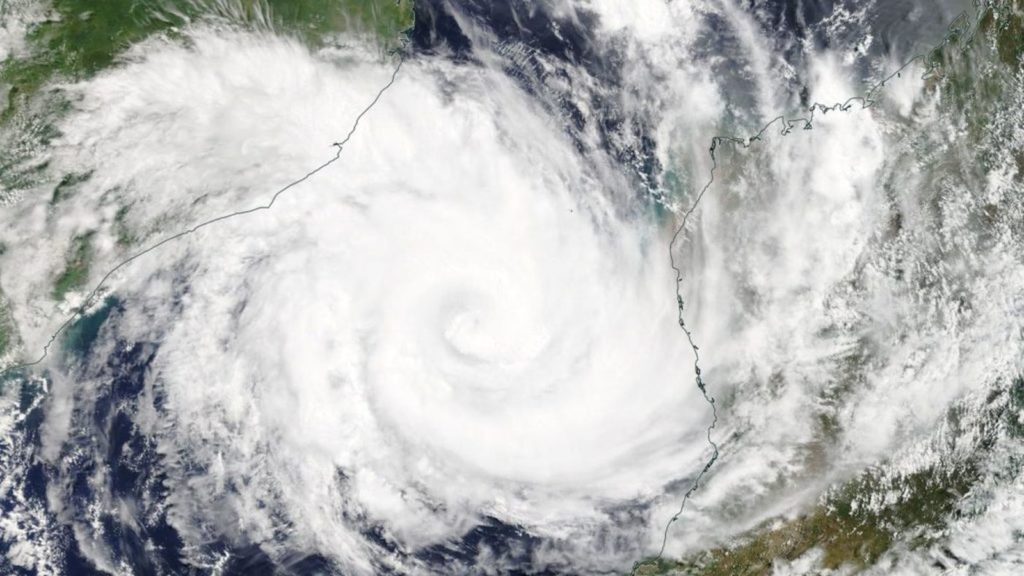
Tropical Cyclone Idai is currently posing a massive risk for the population of Mozambique as it slowly swirls its way towards the country’s eastern coastline.
Read more: What you need to know about Tropical Cyclone Idai, set to strike Mozambique this week
At last count by MeteoFrance, the storm has sustained winds of just under 150km/h radiating some 56km from its core.
To put this storm’s power into perspective, meteorologists and weather enthusiasts have taken to Twitter with animations, stills, and satellite imagery of the storm.
These are the latest:
#Tropical #Indian_Ocean #18S #Idai ECMWF animation 13/0001UTC data pic.twitter.com/ZXTyx8qafQ
— Mike Trigger (@T2mike) March 13, 2019
Intense tropical cyclone #Idai's latest track shows the storm slowly moving westward towards #Mozambique. Idai is expected to make landfall on Thursday evening as a category 3 storm just north of #Beira with winds of 180 km/h. More updates on #eNCA DStv channel 403. #CycloneIdai pic.twitter.com/KEJaqiWHYw
— eNCAWeather (@eNCAWeather) March 13, 2019
Tropical Cyclones can be monitored through their aerosol signature, as sea salt is "sprayed" by wind gusts
— Copernicus EU (@CopernicusEU) March 13, 2019
Here is #Idai as seen by #Sentinel5P 🇪🇺🛰 yesterday
It is forecast to make landfall in the Sofala Province of Mozambique on 14 March with max sustained winds of 200-210 km/h pic.twitter.com/tNswbYQUKl
Buoy in the southeast eyewall of Cyclone #Idai reporting a central pressure of 996.7 hPa. Buoy is not reporting wind information. pic.twitter.com/JBlgQiInw7
— Mike Adcock (@MikeAdcockWx) March 13, 2019
TC #Idai is tracking toward the WSW and likely strikes #Mozambique near #Beira Thursday night. Dangerous storm surge near & S of landfall with destructive winds and flooding rains across C Mozambique Thursday and Friday. Rain can persist into Saturday. pic.twitter.com/5i5TcmBbBT
— Jason Nicholls (@jnmet) March 13, 2019
⛅️VIDEO FORECAST FOR TODAY AND THURSDAY🌩️
— AfricaWeather (@AfricaWeather_) March 13, 2019
– Cyclone #Idai can be seen in the top right of the video & is expected to make landfall during Thursday with the strongest winds on the western & southern flank🌀. @landbou @ReenvalSA @AgriSAOfficial @WMO @StormReportSA1 pic.twitter.com/mgo0tx5heu
Cyclone Tropical #IDAI 970hPa le 13/03 10h 19.4S/39.5E > ouest 9km/h ® 1650km https://t.co/xTo7vXLJ8j pic.twitter.com/9cspa1NQY9
— Lionel (@meteo_reunion) March 13, 2019
Latest Cloud Top Height Image gives an amazing view of tropical #cyclone #idai in the Mozambique channel … that's one feisty storm out there pic.twitter.com/1HVURQagsh
— 🌩️SAWX SA Weather 🇿🇦 (@sawx_sa_weather) March 13, 2019
Dawn reveals #Cyclone #IDAI crossing #Mozambique Channel. Winds 95 knots. Some dry air wrapped into it, giving it that cinnamon-roll look. (Hungry yet?) It could pass close to port city of Beira (pop. ~534K) late tomorrow night. pic.twitter.com/bVeX9PyvPa
— Josh Morgerman (@iCyclone) March 13, 2019
Animated imagery might demonstrate it a bit better. #idai #tropicalweather #cyclones pic.twitter.com/3ZSpPSXw7H
— Jesse Kay (@JesseKayWX) March 13, 2019
Tropical Cyclone Idai is set to make landfall in Mozambique on Thursday, and will likely bring torrential rain and damaging winds to the African country.
For those in Mozambique and surrounds, follow the latest public advisories issued by the country’s national meteorological institute here.
Feature image: NASA Worldview, Earth Observing System Data and Information System (EOSDIS)


