MTN South Africa has once again emerged as the country’s top-performing mobile network, securing the highest score in the Q2 2025 MyBroadband Network Quality…
Updates: What you need to know about Tropical Cyclone Idai, set to strike Mozambique this week

Update, 14 March, 6pm: Just hours away from Tropical Cyclone Idai’s landfall, we detail how and where to track the storm online using social media, official sources, and nifty tools.
Update, 14 March, 10am: MeteoFrance based on Reunion has issued an update on the wind speed and location of Tropical Storm Idai, which has regained its “Intense” moniker.
As of 10am Reunion time, the storm packed a sustained wind speeds of 175km/h, with gusts of up to 250km/h. That makes it an equivalent Category 3 hurricane.
It’s positioned at approximately -19.8 degrees south, 37.1 degrees east, moving west at around 15km/h.
The cyclone is set to impact the Mozambique coastline just north of Beira later today.
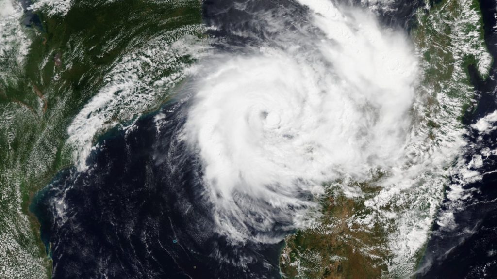
Update, 13 March, 10am: We take a look at the latest satellite loops, stills and information coming from MeteoFrance here.
Update, 12 March, 9am: Tropical Cylone Idai has weakened slightly, losing its “intense” moniker in the early hours of Tuesday morning, AccuWeather’s senior meteorologist Jason Nicholls tweets.
#Idai has weakened slightly to a TC but will likely regain intense TC intensity Tuesday night or Wednesday. Idai has started to move toward the SW and will strike C #Mozambique late Thursday night or Friday. pic.twitter.com/6zjJYTPw6F
— Jason Nicholls (@jnmet) March 12, 2019
The storm is however set to “regain intense TC intensity Tuesday night or Wednesday”.
The current track has Idai’s landfall around the middle of the country’s eastern coastline on Thurday night or Friday morning.
Update, 11 March, 7pm: MeteoFrance has issued an update with revised position of Tropical Cyclone Idai.
“Currently close to Juan de Nova Island in the Mozambique Channel, accompanied by gusts at 250km/h, it should reach the country in the day of Friday,” the weather service tweeted on Monday evening.
#Cyclone tropical intense #IDAI || Actuellement proche de l’Île Juan de Nova dans le canal du Mozambique, accompagné de rafales à 250km/h, il devrait atteindre le pays dans la journée de vendredi. Suivez l’évolution de la situation : https://t.co/IW70n0hBB9 pic.twitter.com/cOjY4X927W
— Météo-France (@meteofrance) March 11, 2019
Original article: We don’t often write about tropical cyclones, but when we do, they’re usually occupying the small Mozambique Channel between its namesake and Madagascar. And this week, Tropical Storm Idai is bearing down on the east African nation.
Officially called Intense Tropical Cyclone Idai, the cyclonic storm is the 11th in total and tenth named disturbance of the south-west Indian basin’s tropical storm season.
Cyclone Tropical Intense #IDAI 960hPa le 11/03 10h 17.3S/43.0E > quasi-stationnaire ® 1350km https://t.co/oDMWEYLYz0 pic.twitter.com/qe96LOW7wp
— Lionel (@meteo_reunion) March 11, 2019
The storm, which formed off the coast of Mozambique on 4 March, wasn’t much more than a depression when it drifted inland, but nonetheless resulted in the deaths of at least 28 people in Mozambique and Malawi.
It then moved eastward, out towards the Mozambique Channel. And as of 11 March, the depression has grown into an intense cyclonic system.
#Tropical #Indian_Ocean (SW) #18S #Idai Image 11/0500UTC. Tracks 11/0001UTC GFS GEM ECMWF and ensembles GEFS GEPS and ECMWF. MeteoFR Reunion track cone 11/1000LOCAL time. #Madagascar #Mozambique pic.twitter.com/e1S0wDPpA2
— Mike Trigger (@T2mike) March 11, 2019
Idai is now is wind speeds on par with a Category 4 hurricane. That’s around 215km/h.
According to MeteoFrance, the storm is currently off the western coast of Madagascar, but will begin to travel west towards Mozambique later this week.
Tropical Cyclone Idai set to strike the country around Beira on Friday 15 March according to the latest advisory.
Mozambique is no stranger to devastating tropical storms. In 2017, Tropical Cyclone Dineo (feature image) ripped through the country, Zimbabwe and northern South Africa.
This is a developing story, and will be updated with new information once made available.
Feature image: Tropical Cyclone Idai on 11 March, by Joint Polar Satellite System (@JPSSProgram) via Twitter