South Africa’s creators, coders and founders are under pressure to do more with less. Whether you’re running a meme page from Mitchells Plain, debugging…
Google Maps will help you catch public transport with ridesharing, cycling options

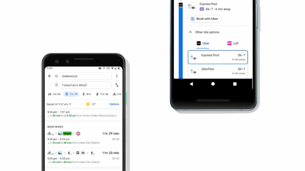
Google Maps will now help users get to their public transport stations by suggesting ridesharing and cycling options available on the route, Google announced on Tuesday.
This means that when you opt for public transport to get to your destination, Google Maps will now show you cycling routes and ridesharing options like Uber, to help you get catch your bus or train.
The new feature combines some of Maps’s current transit options to optimise public transport travels, rather than suggesting you walk to the station you’re looking for.
“If you’re taking a ridesharing vehicle, you’ll see helpful information about each leg of your trip: how much your ride will cost, how long the wait is, if there’s traffic on your ride, and when your bus or train departs,” Google explained on its blog.
Users who opt for cycling will see relevant information and cycling routes as well.
“All of this information is automatically factored into your total travel time and ETA so you can know exactly when you’ll get to your destination,” Google further noted.
The update joins Maps’s other commuter-orientated updates in 2019, including Live View AR navigation, adding bike sharing station information in some cities, and alerting users of crowded trains and bus delays.
The Google Maps feature will roll out in 30 countries around the world over the next few weeks, but has not said if South Africa will be one of them.
Feature image: screenshot, Google