Chinese consumer electronics company Honor is set to unveil its latest lineup of smart devices for the South African market. How about we forecast…
GIFs of Hurricane Dorian show the fearsome ferocity of a Cat 5 storm

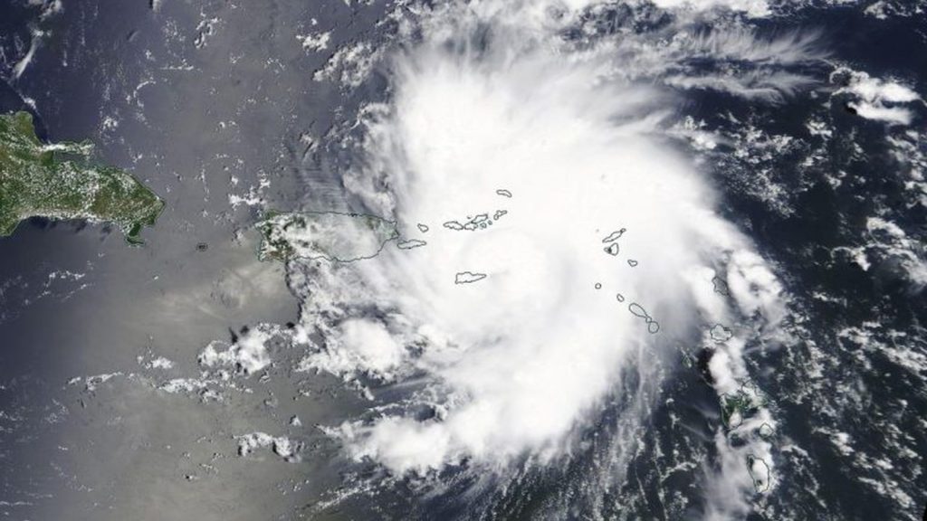
When we first wrote about Hurricane Dorian late last week, the cyclonic storm was packing Category 1-strength winds and bearing down on Puerto Rico.
Three days later, Dorian is now a Category 5 storm, and will be one of the most powerful to ever strike the Bahamas.
NEW: #Dorian is now a category 5 #hurricane with 160 mph sustained winds. The eyewall of this catastrophic hurricane is about to hit the Abaco Islands with devastating winds. Next advisory: https://t.co/tW4KeFW0gB pic.twitter.com/oFspgN0XbT
— National Hurricane Center (@NHC_Atlantic) September 1, 2019
According to the latest update from the US-based National Hurricane Centre (NHC), the storm now packs sustained winds of just under 260 km/h.
Note, that’s sustained. It doesn’t factor in the stronger gusts.
On radar, Dorian is a monster too. A well-defined void is surrounded by a fierce vortex of cloud.
A slew of GIFs posted to Twitter my meteorologists demonstrate just how powerful this storm really is.
#Dorian, now a potentially catastrophic Category 5 hurricane, is mesmerizingly beautiful as a cyclone; yet utterly horrifying given the reality of what the Abacos and Grand Bahama Islands are about to face. pic.twitter.com/JLeWxZZ4L8
— Steve Bowen (@SteveBowenWx) September 1, 2019
#Dorian 30-second resolution GOES-16 loop over a half hour period shortly after sunrise. On its way toward direct impact of Great Abaco later today #Bahamas pic.twitter.com/h4uUuD2Gmg
— Mike Umscheid (@mikeumsc) September 1, 2019
First visible images of category 5 monster #Dorian pic.twitter.com/kMwdFVPkkq
— Allan Huffman (@RaleighWx) September 1, 2019
#Dorian's eyewall will unleash tornadic-like destruction .. as EF3 (+) winds last for hours near RMW (radius of maximum winds) #flwx #gawx #scwx #ncwx pic.twitter.com/CvUR6JLd0e
— Greg Postel (@GregPostel) September 1, 2019
#Dorian hits Category 5 intensity as it’s about to hit the northern Bahamas. Official notice from NHC on the 8 AM advisory. pic.twitter.com/DI0t8IRf4H
— Alex Lamers (@AlexJLamers) September 1, 2019
Sunrise over the eye of intense hurricanes viewed via 30-second imagery from #GOESEast never gets old https://t.co/ereZel5yE9. My thoughts this AM are with #GreatAbaco and the rest of the Northwest #Bahamas where #Dorian's ferocious eyewall will come ashore in the next few hours pic.twitter.com/I7LtFDu9kp
— Jack Sillin | weather.us (@JackSillin) September 1, 2019
Even if you’re far from the storm’s impact, these loops are terrifying.
The NHC has adjusted its track from a few days ago. Where it predicted the storm would make landfall along Florida’s eastern coastline, it’s now more likely to skirt along the coast.
But of course, these are merely predictions. No one knows what the storm will actually do in 48 hours time. But at the moment, the Bahamas is bearing the full brunt of the storm.
Where to track Hurricane Dorian online
Follow the storm’s progression through the NHC’s official Twitter account, and the hashtag #Dorian.
Meteorologist Matt Lanza has also put together a stellar Twitter list of users tracking the storm.
Feature image: Hurricane Dorian as a Category 1 storm on 28 August 2019, by NASA Worldview/Earth Observing System Data and Information System (EOSDIS)